- Thumbnail
- Resource ID
- 27f53244-3c2b-11ea-85eb-02f25c5c7296
- Title
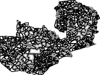
- Ward Boundaries of Zambia
- Date
- Jan. 21, 2020, 2:51 a.m., Publication
- Abstract
- This feature represents the wards of the Republic of Zambia. Wards are delineated by the Electoral Commission of Zambia (ECZ) and the Central Statistics of Zambia (CSO) for the purpose of the population and housing census and elections.
wards are delineated once in a decade during the census mapping exercise.
Source: Electoral Commission of Zambia (ECZ) and the Central Statistics of Zambia (CSO)
- Edition
- --
- Owner
- michael.phiri
- Point of Contact
- Phiri
- Purpose
- --
- Maintenance Frequency
- None
- Type
- not filled
- Restrictions
- formal permission to do something
- License
- Not Specified
- Language
- eng
- Temporal Extent
- Start
- --
- End
- --
- Supplemental Information
- No information provided
- Data Quality
- The data is created and supplied by the ECZ and the CSO who are the mandated institutions.
- Extent
-
- long min: 21.998040875000100
- long max: 33.708576224000100
- lat min: -18.075164000000000
- lat max: -8.224359999999930
- Spatial Reference System Identifier
- EPSG:4326
- Keywords
- no keywords
- Category
- Boundaries
- Regions
-
Global
,
Africa
,
Southern Africa
,
Zambia